Difference between revisions of "Sumner/Glenwood"
m (Protected "Sumner/Glenwood" [edit=sysop:move=sysop]) |
|
(No difference)
| |
Revision as of 10:39, 1 May 2010
Sumner-Glenwood – Between Emerson Avenue N, Girard Terrace, Glenwood Avenue, Lydale Avenue North, and 11th Avenue North
Minneapolis’ Jewish immigrants first settled near Hoag and Oak Lakes (both gone) after escaping the horrifying pogroms of Eastern Europe.(1) With little money, and at the behest of prejudiced Protestant landowners, the sizeable population moved to the least-desired section of Minneapolis—a former bog, Sumner-Glenwood contained some of the worst soil in the city. Garment factories and other nearby industries (that would resemble sweat shops today) hired Jewish men as cheap labor. (2) The community used meager pay and quickly established synagogues, schools, and commercial strips on Glenwood Avenue and Sixth Avenue North. (3)
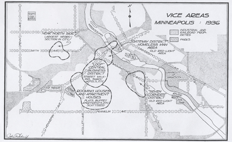
"Vice Areas in Minneapolis, 1936"
North Minneapolis already carried a negative reputation among the city elite—this was the product of anti-Semitism. Time progressed, as did local attitudes towards Jewish citizens, and this affected the financial standing of many Jewish families for the better. As they climbed the social ladder, Jewish families left Sumner-Glenwood for suburban neighborhoods further north.
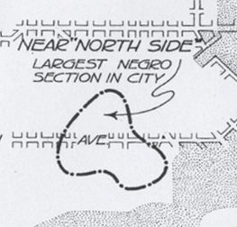
The transitory neighborhood continued to attract negative attention as Minnesota’s African-American population swelled and replaced Jewish people. In 1936, Minnesota officially recognized 6th Avenue North as the epicenter of the city’s “Largest Negro Settlement.”(4) The same study identified the neighborhood as concentrated place of “Juvenile Delinquency,” for girls and boys, of which a sizeable proportion included “sex offenses.”(5)
| Close-up of the "Negro" section. |
This designation appeared in a map of Minneapolis’ “Vice Areas,” which also identified Loring Park, the Gateway District, the “Loop” (including the future site of the IDS Center), and “Seven Corners” (near the West Bank Firehouse) as problem areas.(6) Ignoring the other districts, The State of Minnesota apparently acted to resolve the issues of Sumner-Glenwood’s “negroes.”
|
Like the queer histories of Rondo Avenue, the West Side Flats, and other vice districts that have vanished, Sumner-Glenwood’s GLBT past is difficult to chronicle based on physical evidence. One can assume that homosexual behavior was an unsaid component of the “social deterioration“ in Sumner-Glenwood,(8) yet this cannot be proven beyond a doubt.
(1) Lewin, Rhoda. The Jewish Community of North Minneapolis. Chicago: Arcadia Publishing, 2001. Page 17.
(2) Ibid.
(3) Ibid.
(4)Schmid, Calvin F. Social Saga of Two cities: An Ecological and Statistical Study of Social Trends in Minenapolis and St. Paul. Minneapolis: The Minneapolis Council of Social Agencies, 1936. Chart 195
(5)Schmid, Charts 191-194.
(6)Schmid, Chart 195.
(7)Zalusky, Joseph, Photographer. "Wrecking property for the Sumner Field Project; North Bryant Avenue is at right and Sumner School at 815 Olson Memorial Highway (Sixth Avenue North), Minneapolis" 4/14/1936. Image available at the Minnesota Historical Society.
(8)Schmid, page 360.
Part of Minneapolis/St. Paul, MN: 100 Queer Places in Minnesota History, (1860-1969), (1969-2010)

